


Boondocking in Michigan: 6 Free RV Campsites (2026)
Michigan’s public-land patchwork is a boondocker’s dream—4.6 million acres of State Forest managed by the Department of Natural Resources and three sprawling National Forests (Huron-Manistee, Hiawatha and Ottawa) managed by the U.S. Forest Service. Each system welcomes free, off-grid camping, but with its own rules on stay limits, permits and where you can park an RV.
This guide cherry-picks six highly rated, regulation-friendly spots—spanning sandy Lake Michigan dunes to the wave-lashed rock of Lake Superior—so you can swap campground crowds for true Great-Lakes solitude.
Need wheels? Motorhomeland.com lets you compare and book RV rentals across the state in minutes. Lock in the rig that fits your style, then point it toward Michigan’s wild side.
TABLE OF CONTENTS
- 1. Quick-Look Map & Fast Facts
- 2. Understanding Michigan’s Land Rules
- 3. Destination Profiles
- 3.1 Nordhouse Dunes – Green Road (Huron–Manistee National Forest)
- 3.2 Upper Manistee River – Government Landing (Huron–Manistee National Forest)
- 3.3 French Farm Lake (Mackinaw State Forest – Michigan DNR)
- 3.4 Hovey Lake Campground (Hiawatha National Forest)
- 3.5 Lake Perrault Dispersed (Ottawa National Forest)
- 3.6 Gratiot River County Park (Keweenaw County Park)
- 4. Field-Tested Michigan Boondocking Tips
- 5. Frequently Asked Questions (FAQs)
- 5.1 Is dispersed (boondock) camping legal in Michigan?
- 5.2 Do I need a permit or pass?
- 5.3 How long can I stay in one spot?
- 5.4 Can I have a campfire?
- 5.5 What RV size works best for Michigan’s forest roads?
- 5.6 Are pets allowed at these free camps?
- 5.7 Where can I dump tanks and refill fresh water?
- 5.8 Is winter boondocking possible?
1. Quick-Look Map & Fast Facts
Use the interactive map below to visualize each free camping area, then skim the table for at-a-glance logistics. Pro-tip: download the map for offline use before you leave 4G territory.
| Boondocking Spot | Forest / Zone | Best for RV Size |
|---|---|---|
| Nordhouse Dunes – Green Rd | Huron-Manistee NF (USFS) |
Vans & < 24 ft rigs (sandy) |
| Upper Manistee River (Gov’t Landing) |
Huron-Manistee NF (USFS) |
Up to ~30 ft (site-dependent) |
| French Farm Lake | Mackinaw State Forest (DNR) |
Vans & < 25 ft trailers |
| Hovey Lake Campground | Hiawatha NF (USFS) |
22 ft; tight loops |
| Lake Perrault Dispersed | Ottawa NF (USFS) |
High-clearance vans / truck campers |
| Gratiot River County Park | Keweenaw County Park | Rugged vehicles & tents |
2. Understanding Michigan’s Land Rules
Below you’ll find exactly how the rules change depending on who manages the ground beneath your tires. Michigan splits “free camping” across three main land-owner categories, each with its own stay limits, permits and fire policies. Skim the comparison table, then dive into the bullet-point cheat sheets for quick compliance.
2.1 State Forest Dispersed Camping (Michigan DNR)
- Camp Registration Card – fill out PR4134, seal in a zip bag, staple to a tree or stake before setting up.
- Location rule – choose a spot >1 mile from any State Forest Campground and away from “No Camping” signs.
- Vehicle parking – keep wheels within 50 ft of an open forest road or trail.
- Stay limits – 15 consecutive nights (extended to 21 nights 1 Oct–1 May); move ≥1 mile to reset the clock.
- Fires & wood – use existing rings, check daily burn ban; gather only dead & down wood on-site.
2.2 National Forest Dispersed Camping (US Forest Service)
- Freedom with caveats – dispersed camping allowed almost anywhere unless specifically closed.
- Stay limits – 14 days (Huron-Manistee) or 16 days (Ottawa); afterwards move ≥5 miles (Ottawa NF rule).
- Setbacks – standard 200 ft from lakes, rivers & trails; 400 ft from Lake Michigan shoreline inside Nordhouse Dunes Wilderness.
- Motor Vehicle Use Map (MVUM) – download for your ranger district to confirm which roads allow RV traffic.
- Campfires – permitted in existing rings unless fire restrictions posted; buy/burn local wood to stop invasive pests.
2.3 County, Municipal & Recreation Passport Nuances
- Michigan requires a Recreation Passport (annual sticker) on any vehicle accessing state-managed lands—including when you’re only passing through to reach a dispersed site in State Forests.
- Some shoreline pull-outs, like Gratiot River County Park, fall under county rules; stay limits and fire policies are posted at kiosks—obey on-site signage.
- Always pack out all trash; burying or burning refuse is illegal on both state and federal lands.
Master these basics now and you’ll avoid fines, protect Michigan’s wild places, and—most importantly—enjoy stress-free nights under the Great Lakes sky.
3. Destination Profiles
3.1 Nordhouse Dunes – Green Road (Huron–Manistee National Forest)
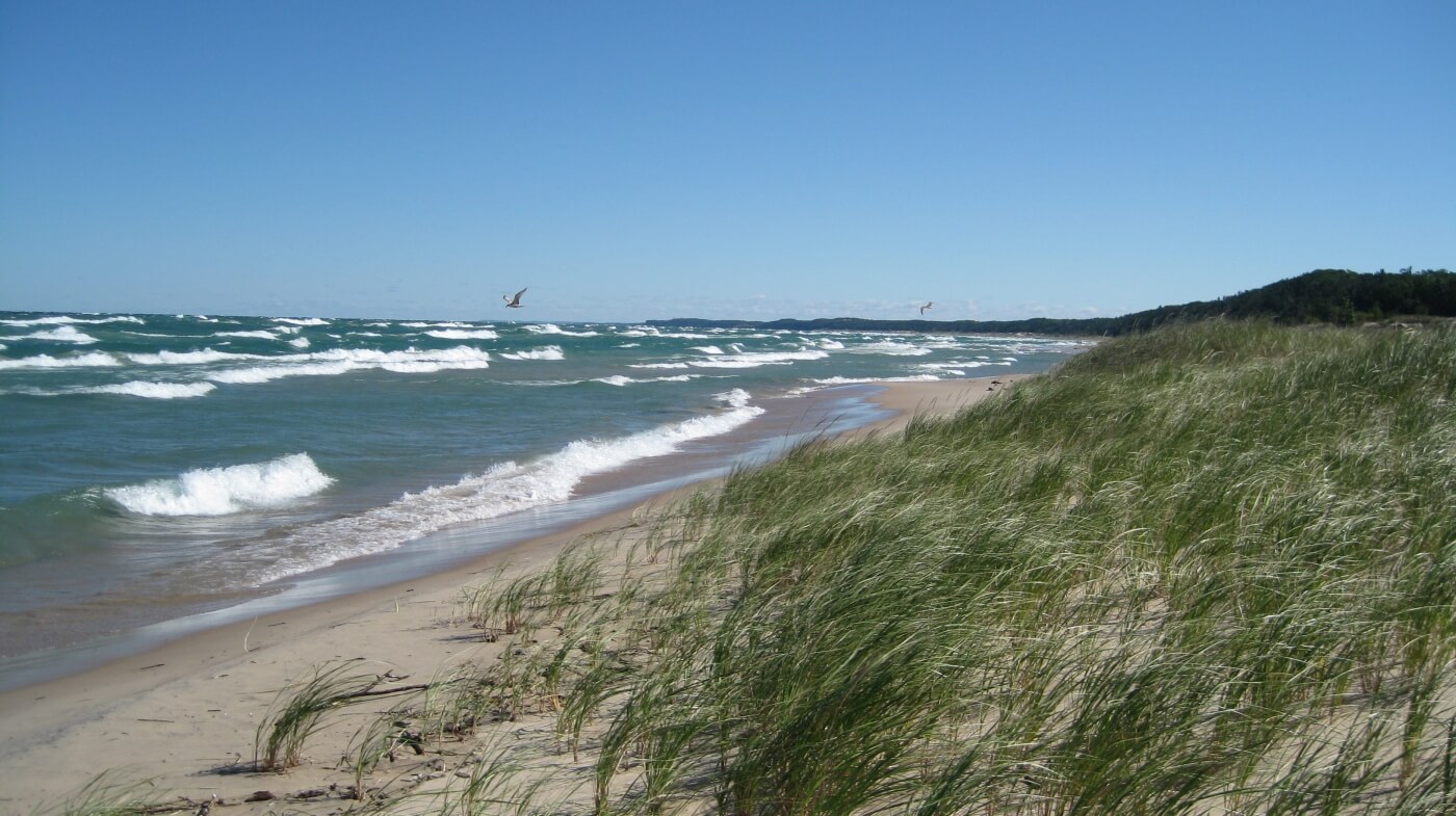
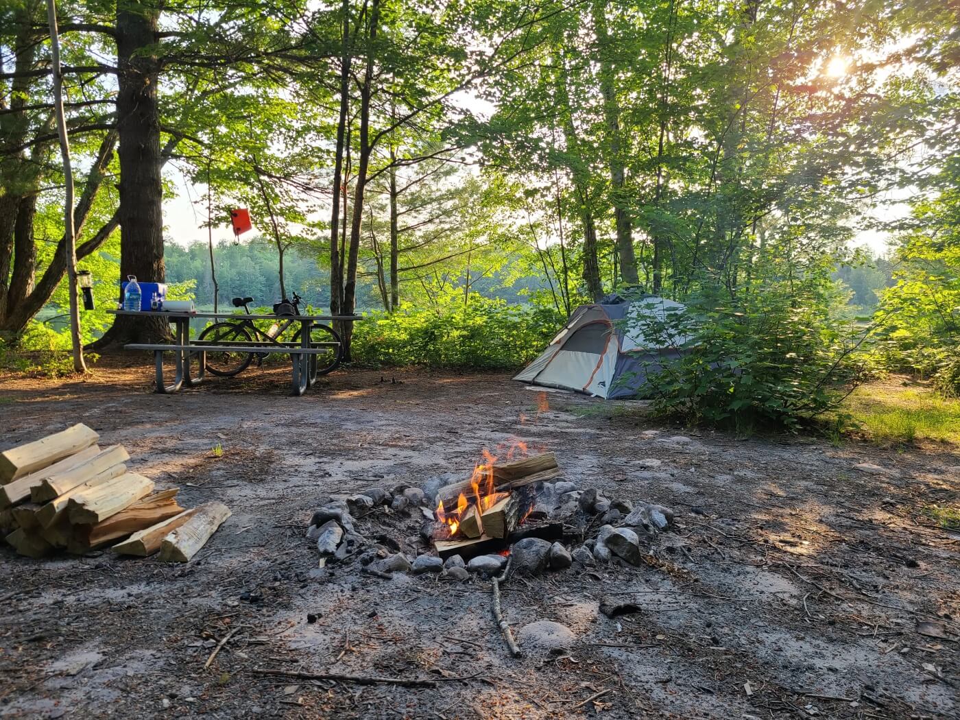
Stretching for four miles along the big-lake horizon, Nordhouse Dunes Wilderness protects 3,450 acres of rolling, 80-foot sand hills backed by jack-pine savanna and interdunal ponds. This is the only federally designated wilderness on Michigan’s Lower Peninsula shoreline, and it feels it—no motorized traffic, no boardwalks, just the thrum of Lake Michigan waves and the scent of beach-grass. Green Road (FR 5353) is the main RV-legal entry, but once you park, everything turns to footpaths winding over soft sand to camps tucked in the pines. Arrive mid-week and you might score an empty stretch of beach at sunset; arrive late Friday and you’ll hustle to maintain the required 400-foot setback from the water.
Because the access road is sandy and wash-boarded, rigs longer than about 24 ft risk bogging or high-centering. Vans and pop-tops rule here. Water is non-potable (filter the shallow ponds or pack it in) and cell bars are elusive—download maps first.
- Forest / Zone: Huron–Manistee National Forest – Nordhouse Dunes Wilderness (USFS)
- Access: 6 mi west of US-31 via W. Forest Trail Rd → Green Rd; last 2 mi deep sand, high-clearance recommended
- Camping style: Walk-in dispersed sites >400 ft from Lake Michigan, >200 ft from ponds/trails; no vehicle-side camping inside wilderness
- Fires: Allowed only in existing rings inland; strictly prohibited on open sand or below high-water line (ticketable offense)
- Facilities: Vault toilet at day-use lot; no trash, no water
- Cell signal: Sporadic 1-bar Verizon on dune crests; none at trailhead
- GPS: Trailhead parking 44.11010, -86.40076
3.2 Upper Manistee River – Government Landing (Huron–Manistee National Forest)
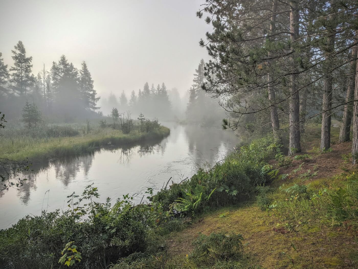
The Upper Manistee River slices through hardwood ridges like a curling green ribbon, famous among fly-fishers for its brook and brown trout hatches. Just south of M-72, a graded forest lane drops to Government Landing, a dispersed gravel loop perched on a gentle river bend. Sites are shaded by old red pines, far enough apart for genuine privacy, yet roomy enough for small travel trailers. The constant hush of current and the hoot of barred owls replace generator chatter; sunrise fog rising off the river is your morning show.
Anglers launch drift boats from the primitive ramp, while paddlers float an easy 8-mile run down to CCC Bridge. Even if you don’t fish, the river trail network offers flat, family-friendly hikes carpeted in spring trillium. The road in is firm gravel but narrow—anything longer than 30 ft will struggle to swing through the loop.
- Forest / Zone: Huron–Manistee National Forest – Cadillac-Manistee Ranger District
- Access: From Kalkaska, 16 mi west on M-72 → NF-road 5717 (signed); 1 mi south to riverside loop
- Camping style: 8–10 leveled gravel pads; first-come, first-served; suitable for vans up to ≈30 ft trailers or C-class
- Fires: Metal fire rings at every pad; follow daily USFS fire-danger postings
- Facilities: One vault toilet; no potable water—river filtering required
- Cell signal: Weak AT&T/Verizon 1–2 bars at entrance, drops riverside
- GPS: River loop 44.26327, -85.88867
3.3 French Farm Lake (Mackinaw State Forest – Michigan DNR)
Just three miles west of the Mackinac Bridge, French Farm Lake offers a surprising pocket of wildness in an otherwise tourist-centric corner of the Lower Peninsula. The 700-acre kettle lake is rimmed by black spruce bog and sand jack-pine flats, providing loons at dawn and star-filled skies after the day-trippers retreat to their hotels in Mackinaw City. A short spur off Wilderness Park Drive leads to several sandy pull-outs and a handful of shaded clearings—big enough for vans and smaller trailers—spaced along the water’s north shore. Early summer brings a chorus of tree frogs; autumn rewards you with fiery maple reflections lapping at the shoreline. Weekdays, you may share the lake with nothing but kayaks and the whistle of distant freighters in the Straits.
- Forest / Zone: Mackinaw State Forest (Michigan DNR)
- Access: 4 mi west of I-75 Exit 337 via Wilderness Park Dr → unnumbered sand spur; firm but narrow, best for rigs < 25 ft
- Camping style: Dispersed lakeside clearings; Camp Registration Card (PR4134) must be posted on every party
- Fires: User-built rings permitted unless daily burn ban; gather only dead & down wood
- Facilities: None—pack out trash; filter lake water
- Cell signal: Generally good (2–3 bars) thanks to nearby town towers
- GPS: Main lakeside pull-out 45.75278, -84.76617
3.4 Hovey Lake Campground (Hiawatha National Forest)
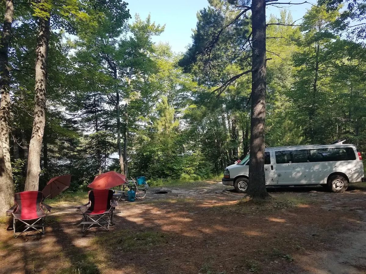
Tucked inside the cedar-lined backroads south of Munising, Hovey Lake Campground feels far wilder than its modest eight sites suggest. The tannin-stained, 80-acre lake is framed by bog mat and white pine, echoing with sandhill cranes in May and barred owls after dark. Each campsite sits just a few steps from the water, separated by thick understory for privacy — perfect for photographers chasing misty sunrise reflections or paddlers launching packrafts for the short portage into nearby Indian Lake. Access is via a single-lane gravel loop with tight bends; trailers longer than 22 ft may scrape branches or struggle to back into the compact pads. The reward for smaller rigs is silence: no hookups, no generators after 10 p.m., and usually no cell reception.
- Forest / Zone: Hiawatha National Forest – Munising Ranger District
- Access: From Munising, 12 mi south on M-94 → FR 2258; final 2 mi narrow gravel, slow speeds
- Camping style: 8 back-in pads along lake loop; first-come, first-served; ideal for vans and C-class <22 ft
- Fires: Established metal rings at every site; purchase local firewood at M-94 convenience stops
- Facilities: Vault toilet, picnic table at each pad; no potable water source—bring jugs
- Cell signal: Effectively none—download offline maps and weather forecasts ahead of time
- GPS: Hovey Lake Campground
3.5 Lake Perrault Dispersed (Ottawa National Forest)
Hidden deep in the hardwood highlands just south of the Keweenaw Peninsula, Lake Perrault rewards the determined boondocker with mirror-flat sunrises, loon lullabies, and a night sky free of city glow. The 50-acre kettle lake anchors a wedge of maple–birch forest punctuated by snowmobile trails and old logging spurs; autumn turns every shoreline tree into a stained-glass panel of crimson and gold. A narrow sand track branches off FR 2160 and threads through young aspen before dead-ending at half-a-dozen primitive clearings right on the water. Sites are small—best suited to lifted vans, truck campers or short trailers—but the trade-off is utter seclusion: on weekdays you may share the lake only with beavers and the occasional ATV.
- Forest / Zone: Ottawa National Forest – Kenton Ranger District
- Access: From U.S. 45 in Kenton, 8 mi west on FR 2160; last 0.7 mi single-lane sand spur—4×4 or careful momentum
- Camping style: 6 lakeside pads; first-come, first-served; stay limit 16 nights, then move ≥5 mi (ONF rule)
- Fires: Use stone rings already in place; verify district-wide fire status before lighting up
- Facilities: None—dig catholes 6–8 in deep, 200 ft from water; pack out trash
- Cell signal: Zero bars—consider a satellite messenger
- GPS: Perrault Lake Campground
3.6 Gratiot River County Park (Keweenaw County Park)
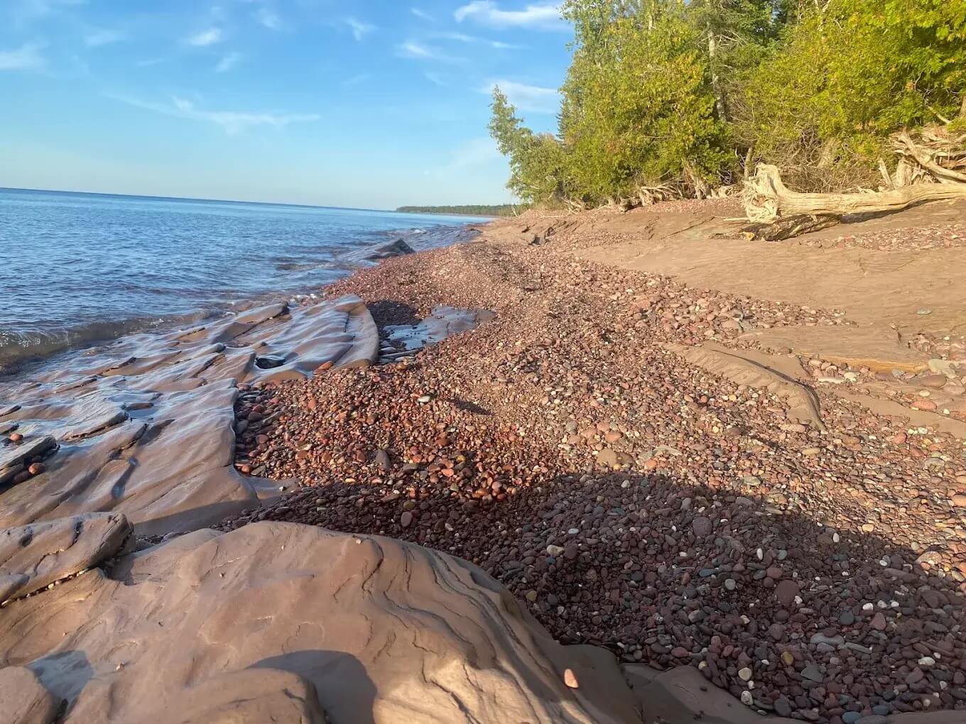
Where the Gratiot River tumbles out of basalt bedrock and meets Lake Superior, you’ll find one of the Upper Peninsula’s last truly wild public beaches. Gratiot River County Park protects 360 acres of boreal shore—black basalt cobbles, wave-polished agates, and windswept spruce—reachable only by a grated clay track that turns slick under rain. Free, undeveloped campsites lie just behind the berm, separated from the surf by a band of dune grass; fall asleep to Superior’s thunder and wake to the possibility of northern lights dancing over the lake. Expect company from rock-hounds on summer weekends but near-solitude the rest of the year.
- Forest / Zone: Keweenaw County Park (county-managed public land)
- Access: From U.S. 41 north of Calumet, 7.5 mi west on Five Mile Point Rd → seasonal dirt park road; muddy after storms, avoid long Class A rigs
- Camping style: Dispersed beach-ridge clearings; no marked pads; stay limit per onsite signage (typically 14 days)
- Fires: Allowed in existing stone circles above high-water line; gather driftwood ≤ 3 in diameter
- Facilities: Vault toilet at trailhead; no water, no bins—pack it all out
- Cell signal: 1–2 bars Verizon on bluff; none on beach flats
- GPS: Bluff parking 47.34329, -88.45207
4. Field-Tested Michigan Boondocking Tips
- Display the right paperwork. Every vehicle on state-managed land needs a Recreation Passport; on State-Forest sites post the free Camp Registration Card (PR4134) on a tree or stake.
- Navigate like a local. Cell coverage vanishes across the Upper Peninsula—download the district’s Motor Vehicle Use Map (MVUM) and offline GPS layers before leaving pavement.
- Pick the right rig for sandy spurs. Forest tracks to Nordhouse Dunes and Lake Perrault are deep sand; rigs ≤ 25 ft with good clearance (or 4×4 vans) avoid getting bogged.
- Burn local, burn legal. Buy or harvest only dead-and-down wood within the county to stop emerald-ash-borer spread, and check the daily DNR/USFS fire-danger map each morning.
- Brace for peak bug season. Mosquitoes, blackflies and stable flies explode June–July near lakes and dunes—treat clothing with permethrin and pack a head-net.
- Lake Superior makes its own weather. Cold fronts can drop temps 20 °F in an hour—carry a fleece and rain shell even in August.
5. Frequently Asked Questions (FAQs)
5.1 Is dispersed (boondock) camping legal in Michigan?
Yes. Michigan State Forests allow free dispersed camping with a posted Camp Registration Card (PR4134), and all three National Forests permit it wherever not specifically closed by order or wilderness regulation.
5.2 Do I need a permit or pass?
- State Forests: Fill out and post the free Camp Registration Card at your site.
- National Forests: Generally no permit; obey Motor Vehicle Use Map (MVUM) road designations.
- Recreation Passport: All motor vehicles on state-managed lands (even just driving through) must display the Michigan Recreation Passport sticker.
5.3 How long can I stay in one spot?
- State Forests (DNR): 15 consecutive nights (21 Oct–May), then move >1 mile.
- National Forests: 14 nights in Huron-Manistee; 16 in Ottawa; then move >5 miles (Ottawa rule).
- County Parks / other public lands: Check kiosk signage—usually 14 nights.
5.4 Can I have a campfire?
Yes—unless a daily burn ban or Red Flag Warning is in effect. Use only existing rings, burn local wood, and keep fires inland or above the high-water line on Great-Lakes beaches.
5.5 What RV size works best for Michigan’s forest roads?
Rigs 25 ft and under—Class B vans, short C-class or small trailers—fit most sandy, single-lane spurs. Larger Class A or fifth-wheels may be restricted to paved boondock pull-outs such as Lakeside county parks.
5.6 Are pets allowed at these free camps?
Yes, but they must be kept under control (leash ≤ 6 ft in State Forests and most USFS areas) and waste must be packed out. Check local ordinances for county parks.
5.7 Where can I dump tanks and refill fresh water?
Use state park modern campgrounds (day-use fee), municipal RV dump stations along I-75 and U.S. 2, or private marinas (small fee). Apps like iOverlander and Campendium list current dump-station status.
5.8 Is winter boondocking possible?
Yes, but many forest roads close or become snowmobile trails from December to April. Choose plowed trailhead lots (e.g., Hovey Lake gate) and carry tire chains, extra propane and an auxiliary heater rated to –10 °F wind-chill.