


Boondocking in Arizona: 5 Wild Places You Can Camp Free in 2026
From saguaro-studded desert near Quartzsite to the cool pines atop the Mogollon Rim, Arizona serves year-round boondockers with millions of public-land acres. Each agency—BLM, the six National Forests, or Kofa National Wildlife Refuge—offers free, no-hookup camping but enforces its own stay limits, permits and fire rules. This guide maps five standout zones, clarifies the rules, and drops exact GPS pins so you can swap crowded campgrounds for true Southwest solitude.
Need wheels? Motorhomeland.com lets you compare and book RV rentals across the state in minutes.
TABLE OF CONTENTS
- 1. Quick-Look Map & Rig Fit Guide
- 2. Know Your Land & Rules
- 3. Signature Boondocking Spots
- 3.1 Mogollon Rim — Forest Road 300 (Coconino National Forest)
- 3.2 West Sedona — Forest Road 525 Designated Areas (Coconino National Forest)
- 3.3 Quartzsite 14-Day BLM Areas (BLM — Yuma Field Office)
- 3.4 Kofa National Wildlife Refuge — Palm Canyon Rd (US Fish & Wildlife Service)
- 3.5 Indian Bread Rocks Recreation Area (BLM — Safford Field Office)
- 4. Desert Boondocking Field Kit
- 5. Arizona Boondocking FAQs
1. Quick-Look Map & Rig Fit Guide
Tap the interactive map to visualize each campsite. Need to know if your rig fits? The mini-table below lists the largest RV size or style that comfortably reaches each spot, so you can decide at a glance.
| Boondocking Spot | Best-Fit Rig Type |
|---|---|
| Mogollon Rim — FR 300 (Coconino NF) |
All rigs to 35 ft Big Class C / small A |
| West Sedona — FR 525 lots (Coconino NF) |
Up to 40 ft Fifth-wheels welcome |
| Quartzsite 14-Day Areas (BLM) |
Any size — 45 ft+ Big-rig friendly flats |
| Kofa NWR — King Rd zone (USFWS) |
High-clearance vans < 25 ft Small trailers |
| Indian Bread Rocks (BLM Safford FO) |
Up to 40 ft with scouting Best for midsize Class C |
*Detailed stay limits, fire rules, and access roads are covered in each destination profile below.
2. Know Your Land & Rules
Arizona’s free-camp promise lives under three different rulebooks. Identify the managing agency before you drop your landing gear—otherwise you could face fines or be asked to leave.
2.1 Who Owns the Dirt?
- Bureau of Land Management (BLM) – Vast low-desert tracts popular in winter (e.g., Quartzsite). No permit in 14-Day Areas; Long-Term Visitor Areas (LTVAs) require a seasonal pass. Stay ≤ 14 days in 28 and move ≥ 25 mi.
- U.S. National Forests (USFS) – Cool pine plateaus like the Coconino and Apache-Sitgreaves. Free dispersed camping with a 14-day limit per Ranger District; consult the forest’s MVUM for legal camping corridors.
- Arizona State Trust Land (ASTL) – Often mistaken for “public land.” A recreational permit (≈ $15/yr individual) is mandatory and only allows a total of 14 camping days statewide per calendar year.
2.2 Core Rules That Apply Almost Everywhere
- 14-Day Stay Limit. BLM & USFS cap you at 14 consecutive days (or 14 total within 28–30 days). After that, relocate the rig as required—25 mi for BLM, ≥ 5 mi for most forests.
- ¼-Mile Water Buffer. State law (ARS § 17-308) bans camping within 1,320 ft of any natural water hole or livestock tank—critical for wildlife.
- Road Setbacks. On National Forest “corridors,” keep your RV within the signed pull-outs or ≤ 300 ft off the open MVUM road. No cross-country driving on desert crust.
- Fire-Restriction Ladder. Stage I = fires only in metal rings; Stage II = no wood or charcoal anywhere. Always verify the daily bulletin before lighting a flame.
2.3 Paperwork Quick Tips
- Print or download the forest’s free Motor Vehicle Use Map (MVUM)—it’s the legal guide to where you can camp off-road.
- Traveling State Trust Land? Buy the ASTL Recreational Permit online before you go; rangers do spot-checks.
- For winter stays ≥ two weeks near Quartzsite, a La Posa LTVA permit covers dump, water, trash and propane fill.
Bottom line: match your plans to the agency’s playbook, carry the right permit, and you’ll roll into camp stress-free—and legal.
3. Signature Boondocking Spots
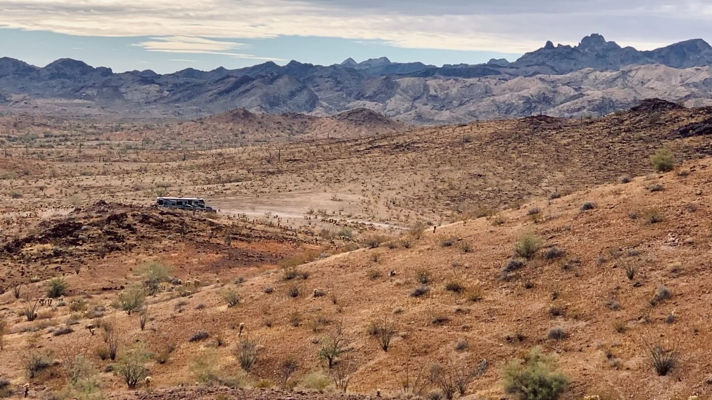
3.1 Mogollon Rim — Forest Road 300 (Coconino National Forest)
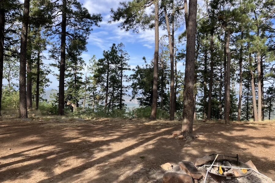
The Mogollon Rim is a 2,000-ft escarpment that marks the southern edge of the Colorado Plateau, offering 100-mile vistas and cool summer temps beneath towering ponderosa pines. Forest Road 300—nicknamed the “Rim Road”—winds 51 miles along the cliff and is peppered with pull-outs where you can park on the edge of forever.
- Land / Zone: Coconino National Forest – Mogollon Rim Ranger District
- Access: From AZ-260 near Forest Lakes, turn onto FR 300; graded dirt/gravel with heavy washboard—drive < 25 mph
- Elevation: 7,500 ft — daytime 70 °F in July, but nights can plunge below 40 °F; pack a 20 °F sleeping bag
- Camping style: Dozens of dispersed pull-outs on west half of FR 300; all rig sizes fit main clearings, scout side spurs
- Services: None — no water, toilets, trash, or dump; nearest full services in Payson or Heber (30–45 min)
- Fires: Existing rings only; Stage I or II bans common May–June — verify daily before striking a match
- Stay limit: 14 nights per 30 days, then move ≥ 5 miles (USFS rule)
- Drawbacks: Rough washboard shakes RVs, popular on summer holidays, windy cliff edge, cold nights even in July
- GPS: FR 300 / FR 9350 pull-out 34.38877, -111.07965
3.2 West Sedona — Forest Road 525 Designated Areas (Coconino National Forest)
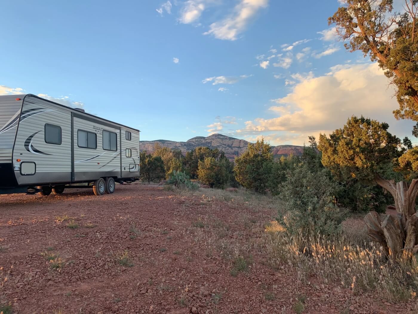
Camping among Sedona’s crimson buttes is a bucket-list goal for many RVers, but years of over-use forced a change: dispersed camping is now limited to eight free, signed lots along FR 525, FR 89B and FR 9570A. Pads are hard-packed caliche big enough for fifth-wheels, yet feel more like dusty parking areas than wild sites. Sunrise paints Doe Mountain gold; by noon, Jeep tours rumble past in clouds of red dust.
- Land / Zone: Coconino National Forest – Red Rock Ranger District
- Access: From US-89A turn onto FR 525; first lot (Surprise) sits 5 mi in on rough, wash-boarded gravel
- Elevation: 4,600 ft — mild winters, triple-digit summer sun; carry reflective tarps
- Camping style: Eight numbered lots only (Surprise, Windmill, Cockscomb, Greasy Spoon, Nolan, Javelina, Angel Valley, Rockview); no roadside pull-outs allowed
- Fires: Year-round ban on wood and charcoal; propane devices with on/off valve only
- Services: Self-contained camping; a few lots may have seasonal portable toilets—do not rely on them
- Stay limit: 14 nights per district, then move ≥ 5 mi
- Drawbacks: Crowded on weekends, heavy dust, constant tour-vehicle traffic, limited privacy
- GPS: Central lot cluster (Windmill) 34.823408, -111.90594
Need traction on red-dust washboard? Filter all-terrain-tire Class C rentals at Motorhomeland.com before you roll.
3.3 Quartzsite 14-Day BLM Areas (BLM — Yuma Field Office)
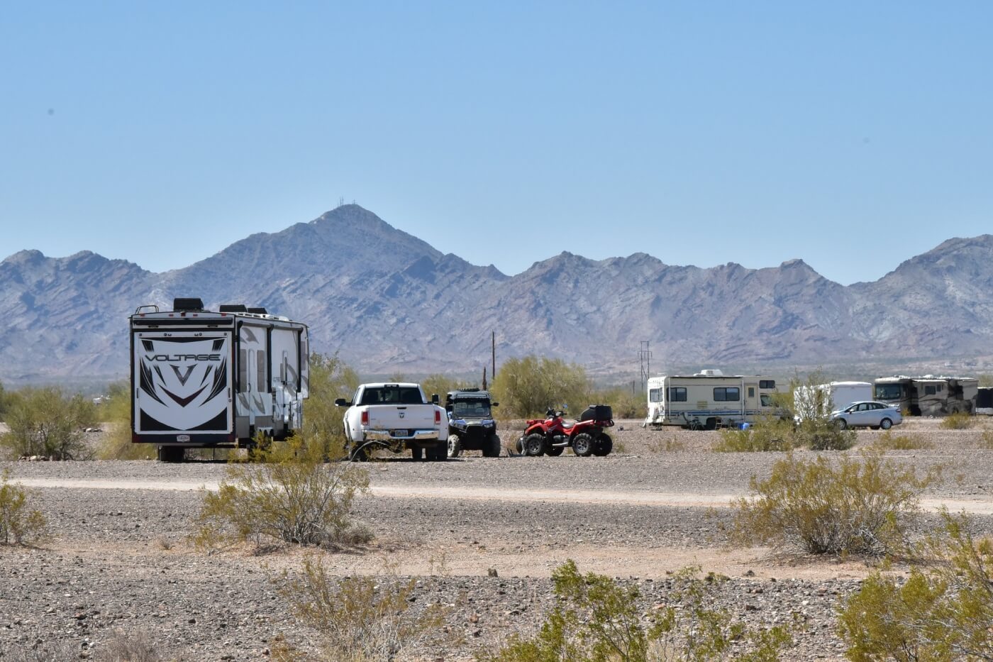
Every winter, hundreds of thousands of RVers converge on the Quartzsite BLM lands, transforming the desert flats into a rolling city of rigs. Five free 14-day zones—Plomosa Rd, Scaddan Wash, Dome Rock, La Posa North and Roadrunner—surround town, while the paid La Posa LTVA sits just south of I-10.
- Land / Zone: Bureau of Land Management — Yuma Field Office
- Access: I-10 Exit 17 → gravel spurs signed for each 14-Day Area
- Elevation: 880 ft — perfect 55–75 °F winters; avoid May–Sept triple digits
- Camping style: Unlimited desert pads; stay ≤ 14 days in any 28-day window, then move 25 mi
- Services: Potable water, multi-lane dump and dumpsters inside La Posa South LTVA ($ fee)
- Fires: Allowed in existing rock rings unless Stage II ban is in effect
- Drawbacks: Massive crowds mid-January, fine dust infiltrates gear, zero natural shade
- GPS: La Posa South LTVA entrance 33.65165, -114.21690
3.4 Kofa National Wildlife Refuge — Palm Canyon Rd (US Fish & Wildlife Service)

Rugged rhyolite spires, towering saguaros and near-black skies define the 665,000-acre Kofa National Wildlife Refuge. Palm Canyon Road leads ten miles toward the only native palms in Arizona; high-clearance vans venture farther into washes like Kofa Queen.
- Land / Zone: Kofa NWR — U.S. Fish & Wildlife Service
- Access: US-95 mile 85 → Palm Canyon Rd; graded gravel, rocky after mile 6
- Elevation: 1,900 ft—prime Oct–March temps; summers > 115 °F
- Camping style: Dispersed pull-outs within 100 ft of existing roads; 14-day total per year
- Services: None—haul all water, fuel and trash; no cell in most canyons
- Fires: Propane or metal fire pans only; no wood collection allowed
- Drawbacks: Rough, tire-shredding roads, zero services, increasing litter, dangerous summer heat
- GPS: King Road dispersed area 33.25391, -114.22304
Caution: Pack at least 1 gal of water per person per day; rescue is hours away.
3.5 Indian Bread Rocks Recreation Area (BLM — Safford Field Office)
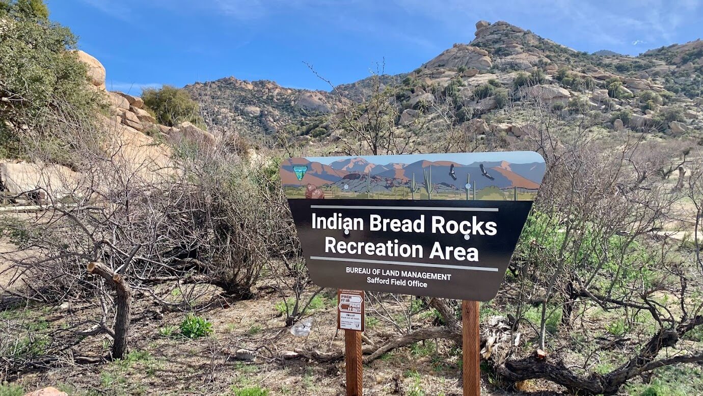
Giant rounded granite boulders give Indian Bread Rocks its bakery-themed name. The maze of alcoves, short scrambles and weather-sculpted caves sits at the foot of the Dos Cabezas Mountains, just 15 minutes off I-10 yet light-years from freeway noise. Sunrise turns the stones peach; after dark, Bortle-2 skies ignite with stars.
- Land / Zone: Bureau of Land Management — Safford Field Office
- Access: From Bowie, drive south on Apache Pass Rd 7 mi → turn west on Indian Bread Rd (graded dirt, heavy washboard) for 2 mi to picnic loop
- Elevation: 4,000 ft — winter highs ~60 °F; summer shade scarce, 100 °F+ common
- Camping style: Numerous dispersed pads among boulders; big rigs (≤ 40 ft) possible but scout tight loops first
- Services: Vault toilet and trash cans at day-use lot; no water, power or dump station
- Fires: Allowed in existing metal grills; bring store-bought wood — local collection banned during Stage II
- Stay limit: 14 days in a 28-day window (BLM rule)
- Drawbacks: Rough washboard access road, limited level pads for big rigs, occasional cattle wander through, some visitor trash
- GPS: Entrance & picnic area 32.2303, -109.5337
Bring binoculars: desert bighorn sheep sometimes graze the Dos Cabezas ridgelines at dawn; Fort Bowie National Historic Site is 10 miles south for a history side-trip.
4. Desert Boondocking Field Kit
- Start every trip with full tanks—and a backup bladder.
- Arizona is arid everywhere. Fill fresh-water to 100 % before leaving town and carry a 5–10 gal portable bladder for mid-trip refills at pay stations in Payson, Quartzsite or Willcox.
- Know the fire ladder.
- Stage I means no open flame outside metal rings; Stage II bans wood and charcoal entirely—propane only. Check restrictions the morning you roll.
- Respect cryptobiotic soil & the quarter-mile water rule.
- Stay on existing tracks and keep rigs > 1,320 ft from natural water holes—state law protects wildlife access.
- Aim tires 5–10 psi lower for washboard roads.
- FR 300 and Indian Bread access roads shake cabinets loose; a small air-down smooths the ride and boosts traction on sand.
- Guard your power from dust.
- Fine silt can cut solar output by 30 %. Rinse panels nightly in Quartzsite and Sedona corridors to keep batteries topped.
- Plan dumps and trash—nothing stays in the desert.
- Use La Posa South dump (Quartzsite), Payson city station or TA Willcox. Gray/black-tank or trash dumping on public land is illegal and jeopardizes access for everyone.
- Download offline maps before the bars disappear.
- Cell signal fades in Kofa canyons and along the Mogollon Rim. Save MVUMs and GPX tracks in Gaia or Avenza and practice paper-map backup.
5. Arizona Boondocking FAQs
5.1 Is it really legal to camp for free in Arizona?
Yes—on most BLM and U.S. National Forest lands, dispersed camping is free and legal unless an area is posted “No Camping.” Arizona State Trust Land is different: it always requires a paid Recreational Permit.
5.2 How does the 14-day rule work?
- BLM & USFS: You may stay up to 14 consecutive days in any 28- or 30-day window.
- BLM 25-mile rule: After 14 days you must move at least 25 miles from the previous spot before restarting the clock.
- State Trust Land: Permit holders get a total of 14 days per calendar year statewide.
5.3 Can I have a campfire?
Only when fire danger is below Stage II. Check the live Arizona fire-restrictions map each morning; under Stage II all wood and charcoal fires are banned—even in rings.
5.4 What’s the quarter-mile water rule?
State law (ARS § 17-308) forbids camping within 1,320 ft / ¼ mile of any natural water hole or livestock tank so wildlife can drink undisturbed.
5.5 Where can I dump tanks and refill fresh water?
- Quartzsite: RV Pit Stop and La Posa LTVA ($) offer dump, potable water and propane.
- Mogollon Rim: Public dump at Green Valley Park (Payson) or Black Mesa Ranger Station (Heber).
- Indian Bread Rocks: TA Travel Center in Willcox (I-10 Exit 340) has 24 h dump and water.
5.6 Will I have cell service?
Expect 2–3 bars near Quartzsite and Sedona trailheads but zero signal in Kofa canyons and long stretches of FR 300. Download offline maps (Gaia, Avenza, Google) before leaving pavement.
5.7 Is monsoon season safe for camping?
Yes—if you avoid washes. July–September storms can send flash-flood walls through low spots at Indian Bread Rocks and Kofa. Choose higher benches and monitor NOAA weather radio.
Still have questions? Drop a comment below or open our live chat—Arizona-based staff usually reply within 24 hours.